City tech wonks add toys to Emanuel’s utility belt
By Elliott Ramos

City tech wonks add toys to Emanuel’s utility belt
By Elliott Ramos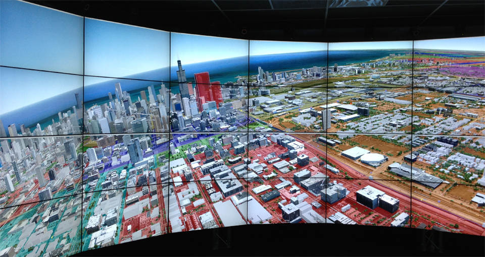
Chicago and Google increasingly have something in common. It’s not that the two share equal prowess in search engine design, or that they outdo one another in swapping cute logos on their core websites. No, the similarity is more philosophical, and it has to do with how they use data.
The city’s archiving and storing data at a breakneck pace and utilizing mapping software to tie disparate city records into new applications. Like Google, which seeks to change how we make personal decisions, the city’s tech trust is seeking to change how officials govern Chicago.
Brett Goldstein, the chief data officer for Chicago’s Department of Innovation and Technology, spoke at the kick-off event for the Urban Sciences Research Coordination Network. This new group includes the city of Chicago, the University of Chicago, the Urban Center for Computation and Data, the Computation Institute and others who seek to use “Big Data” to address social problems ranging from juvenile corrections to energy-use and employment.
Held in February at the hall at the School of the Art Institute of Chicago, the room was packed with tables of data analysts, urban planners, sociologists and developers who sought to use city data to decrypt social problems.
While there, Goldstein touted several projects his department has initiated. Many were in testing stages, amounting to Chicago’s own version of Google Labs.
Within the the walls of the Daley Center, Goldstein’s department creates tools, utilizing the mountains of data to inform city managers about the inner workings of the city — sometimes in real time.
The project names are whimsical, but their use could very well alter the way city departments respond with services, perhaps pre-emptively.
Among the tools: Project Unicorn, which was recently renamed Chirp, on a submission to the Knight News Challenge. The city seeks to use that program “to act on city service issues identified via social media — eliminating the need to visit City Hall, call 311, or download special applications,” according to the project submission.
The tool, currently being tested by Goldstein’s department, would allow the city to monitor location-based Tweets and then respond to requests such as street-light outages or graffiti removal.
The city’s also testing Project Falcon, renamed on another submission to the Knight News Challenge as Scout.
About the grant submission, Goldstein said Scout would “aggregate data sources based on location … Applications built using this interface will enable residents to interact with data in a way that’s structured around their day-to-day lives.”
This is above and beyond the SmartData Platform, a separate program developed with funds from the Bloomberg Mayors’ Challenge, according to a spokesperson from Goldstein’s department. The platform’s purpose is allow City Hall to analyze millions of lines of data in real-time and, according to the city, make “smarter, earlier decisions to address a wide range of urban challenges.” The city won $1-million prize from Bloomberg Philanthropies to spend on the project.
Another effort aims to better visualize data using unconventional techniques. This one, dubbed Project Batman, will utilize an immersive, multi-display system called “The Cave.”
The Cave, housed at the University of Illinois at Chicago, has already been used by researchers to visualize environments or biological models.
The display is reminiscent of the computer used by Tom Cruise’s character Chief John Anderton in the 2002 movie Minority Report. That movie is often cited for its near prescience in predicting the touch-and-swipe interfaces common to iPhones and iPads.
Going on the ‘Grid’
Goldstein cited a need for city officials to get information on an area for planning purposes — or need a handle on what’s happening in real time such as updates during the NATO protests.
Foursquare handles massive archives of location-based data when its users check in to venues. The system that powers it, MongoDB, is used by the likes of Craigslist and bit.ly to maintain “scaleable” databases.
After some creative programming, Goldstein created an in-house system that would tie together incoming information to a defined area like a street block or neighborhood. The resulting project was dubbed: WindyGrid.
“It tells me what is happening now,” Goldstein explained. “I create my polygon over an area and say this is what I want to know about this point in time going forward. So, say I want to watch 911 priority-1 calls and Tweets … If [you] were to call to 911, it would should up [on the grid] within 30 seconds.
“The design of WindyGrid is to allow you to have historical deep dive. So when the COO or chief of staff tells you that we have something popping off at 121 N. LaSalle, here’s a history. It’s there.”
The Department of Innovation and Technology did not comment on which city departments, if any, were currently using WindyGrid.
“You can create conditions to watch, and what we’re rolling out now is automatic notifications,” Goldstein said.
He cited an example of power lines being downed, which a 911 call would result in a cop staying on the scene until staff from the department of streets and sanitation arrive.
“Now, the system accelerates information distribution. This is not complicated. This is just thinking outside of the box.”
Follow Elliott Ramos on Twitter @ChicagoEl email:eramos@wbez.org.